Surveying is an essential part of construction, civil engineering, land development, infrastructure planning, and mapping. Accurate measurements help engineers and surveyors determine distances, angles, elevations, positions, and land boundaries. To perform these tasks efficiently, professionals use different types of survey instruments designed for specific measurement and fieldwork requirements.
Modern surveying has moved far beyond traditional manual methods. Digital levels, total stations, GNSS receivers, laser scanners, and drone-based surveying systems now provide faster data collection and improved accuracy. Understanding the types of survey instruments can help students, surveyors, engineers, and project managers choose the right equipment for different surveying applications.
This guide explains the most commonly used survey instruments, their uses, advantages, and important factors to consider when selecting surveying equipment.
What Are Survey Instruments?
Survey instruments are specialized tools used to measure and determine the location, distance, angle, elevation, and position of points on the Earth’s surface.
Depending on the surveying task, instruments may use optical, electronic, laser, satellite-based, or aerial technologies. Traditional instruments are still useful for basic surveying, while modern digital systems allow surveyors to collect, store, process, and transfer field data more efficiently.
The right instrument depends on factors such as project size, required accuracy, terrain, measurement range, environmental conditions, and available budget.
Types of Survey Instruments
There are many types of survey instruments used in modern surveying. The following are some of the most important ones.
1. Total Station
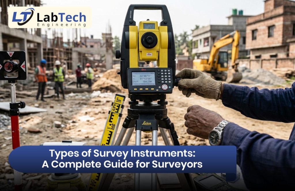
A total station is one of the most widely used modern surveying instruments. It combines the functions of an electronic theodolite and an electronic distance measurement system.
A total station can measure:
- Horizontal angles
- Vertical angles
- Distances
- Coordinates
- Elevations
Modern total stations can store measurement data internally and transfer it to computers or data collectors for further processing.
Total stations are commonly used for construction layout, topographic surveys, boundary surveys, road projects, building construction, and engineering surveys.
2. Theodolite
A theodolite is an optical or electronic instrument used primarily for measuring horizontal and vertical angles.
Although total stations have replaced traditional theodolites in many applications, theodolites are still useful for angle measurement, alignment, construction work, and surveying education.
Digital theodolites provide easier readings and reduce the possibility of manual reading errors.
3. Automatic Level
An automatic level is designed to determine differences in elevation between points. It uses a compensator to automatically maintain a horizontal line of sight.
Automatic levels are commonly used for:
- Leveling surveys
- Road construction
- Building projects
- Drainage work
- Foundation construction
- Elevation measurement
They are relatively simple to operate and provide reliable results when properly set up.
4. Digital Level
A digital level is a more advanced leveling instrument that uses electronic technology to measure elevations. It typically works with a bar-coded staff and can automatically record readings.
Digital levels can improve productivity by reducing manual reading and recording errors. They are particularly useful when high accuracy and efficient data collection are required.
5. GNSS/GPS Surveying Equipment
GNSS, or Global Navigation Satellite System, equipment uses signals from satellites to determine the position of a survey point.
Survey-grade GNSS receivers can provide highly accurate positioning, particularly when used with Real-Time Kinematic (RTK) technology.
GNSS surveying equipment is widely used for:
- Topographic surveys
- Land surveying
- Construction positioning
- Mapping
- Cadastral surveys
- Infrastructure projects
Unlike traditional optical instruments, GNSS systems can determine coordinates without requiring direct line-of-sight between every measured point.
6. Laser Distance Meter
A laser distance meter is a compact instrument used to measure distances quickly using laser technology.
It is useful for building measurements, interior surveying, construction estimation, and short-distance field measurements.
Laser distance meters are portable and easy to operate, making them suitable for tasks where high-range surveying equipment is unnecessary.
7. Surveying Compass
A surveying compass is used to determine directions and horizontal angles relative to magnetic north.
Although modern electronic instruments have reduced its use in advanced surveying, a compass can still be useful for basic land surveys, preliminary fieldwork, navigation, and educational purposes.
8. Measuring Tape
Measuring tapes are among the simplest surveying tools. They are commonly used for short-distance measurements and basic site work.
Different types of measuring tapes are available in various lengths and materials. While they cannot provide the advanced accuracy and data collection capabilities of modern instruments, they remain useful for preliminary measurements and small-scale projects.
9. Plane Table
A plane table is a traditional surveying instrument that allows field measurements and mapping to be performed directly on a drawing sheet.
It can be used for small-area topographic surveys and basic mapping exercises. Although digital surveying technologies are now more common, plane table surveying can still be useful for educational purposes and certain simple field applications.
10. Laser Scanner
Laser scanners are advanced surveying instruments used to capture large amounts of three-dimensional spatial data.
Terrestrial laser scanners can collect millions of measurement points to create detailed 3D representations of buildings, structures, terrain, and other environments.
Laser scanning is commonly used for:
- 3D mapping
- Building documentation
- Structural surveys
- Construction monitoring
- Industrial measurement
- Heritage documentation
This technology is particularly useful when detailed three-dimensional information is required.
11. Surveying Drones and UAVs
Drones equipped with cameras and surveying sensors can collect aerial data over large areas. Photogrammetry software can then process captured images to create maps, orthomosaic images, point clouds, and 3D models.
Drone surveying can significantly reduce fieldwork time for large or difficult-to-access areas.
Common applications include:
- Topographic mapping
- Construction site monitoring
- Land development
- Stockpile measurement
- Road and infrastructure surveys
- Agricultural mapping
Survey Accessories and Supporting Equipment
Survey instruments are often used together with various accessories. These supporting tools help improve stability, accuracy, and field productivity.
Common surveying accessories include:
- Survey tripods
- Prism poles
- Reflector prisms
- Measuring staffs
- Data collectors
- GNSS poles
- Tribrachs
- Batteries and chargers
- Field tablets
- Surveying software
A high-quality tripod, for example, provides stable support for total stations, levels, and other instruments. Similarly, data collectors allow surveyors to record measurements and manage field data digitally.
Applications of Survey Instruments
The different types of survey instruments support a wide range of professional applications.
Land and Boundary Surveying
Survey instruments help determine property boundaries, land dimensions, and coordinates for legal and development purposes.
Construction Surveying
Total stations, levels, and GNSS receivers are widely used to establish building positions, foundation points, columns, roads, and other construction elements.
Topographic Surveying
Surveyors use total stations, GNSS systems, drones, and laser scanners to collect terrain information and create detailed site maps.
Road and Highway Projects
Survey instruments help engineers establish alignment, elevations, cross-sections, and construction control points for transportation projects.
Infrastructure Development
Bridges, railways, pipelines, utilities, and other infrastructure projects require accurate positioning and measurement throughout planning and construction.
Deformation Monitoring
Advanced surveying equipment can be used to monitor changes in buildings, bridges, dams, slopes, and other structures over time.
How to Choose the Right Survey Instrument
Choosing the right surveying equipment depends on the requirements of the project.
Consider the following factors:
Required accuracy: Different projects require different levels of measurement accuracy.
Project size: Large construction or infrastructure projects may require total stations, GNSS receivers, or drone surveying systems.
Terrain: Difficult or inaccessible terrain may benefit from GNSS, drones, or laser scanning technology.
Measurement range: Consider the maximum distance the instrument needs to measure.
Data management: Digital instruments with data storage and software compatibility can make fieldwork more efficient.
Durability: Survey equipment should be able to withstand dust, moisture, temperature changes, and regular field use.
Budget: Select equipment that provides the required features without unnecessary costs.
Maintenance of Survey Instruments
Proper maintenance is important for maintaining surveying accuracy. Instruments should be kept clean and protected from dust, moisture, and extreme environmental conditions.
Optical components should be cleaned carefully using appropriate materials. Batteries should be stored and maintained properly, while tripods, poles, and other accessories should be inspected regularly.
Survey instruments should also be calibrated periodically according to manufacturer recommendations. Regular calibration helps ensure that measurements remain reliable and suitable for professional applications.
Modern Trends in Surveying Equipment
Surveying technology continues to evolve with developments in GNSS, robotics, laser scanning, drones, artificial intelligence, and cloud-based data management.
Robotic total stations can automatically track a prism and reduce the need for manual instrument operation. GNSS receivers provide fast positioning, while laser scanners capture detailed 3D information. Drone-based surveying allows professionals to collect aerial data efficiently across large areas.
These technologies are helping surveyors reduce fieldwork time, improve data quality, and manage increasingly complex projects.
Conclusion
Understanding the different types of survey instruments is important for selecting the right equipment for land surveying, construction, mapping, infrastructure development, and engineering projects. From traditional measuring tapes and levels to modern total stations, GNSS receivers, laser scanners, and drones, each instrument has specific capabilities and applications.
The best surveying equipment depends on project requirements, accuracy, terrain, measurement range, data management needs, and budget. With proper selection, operation, and maintenance, modern survey instruments can improve field productivity, measurement accuracy, and overall project efficiency.
FAQ
1. What are survey instruments?
Survey instruments are tools used to measure distances, angles, elevations, and positions.
2. What is the most common modern survey instrument?
Total stations are widely used for accurate angle, distance, and coordinate measurements.
3. What is a GNSS receiver used for?
It is used to determine accurate geographic positions using satellite signals.
4. What is an automatic level used for?
It is mainly used to measure differences in elevation between points.
5. How do you choose a survey instrument?
Consider accuracy, project size, terrain, range, features, and budget.